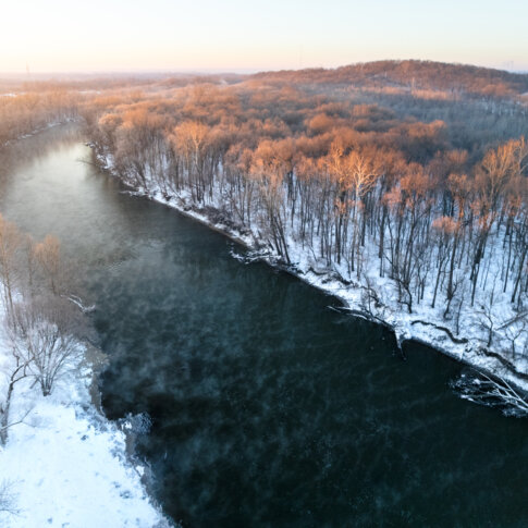
Central Indiana lies within the Wabash River Drainage Basin, with both Hamilton and Marion counties predominantly belonging to the White River Subbasin. Glaciers formed this topography about 20,000 years ago, with the waterways winding and changing shape for thousands of years while establishing White River as the central waterway to this area. Tributaries Stony Creek and Cicero Creek feed into the White River in Hamilton County while Fall Creek and Eagle Creek feed into the White River in Marion County.
The northernmost anchor of the river within Hamilton County lies in the North Reach, from the Lafayette Trace south to 206th Street, which is just south of Strawtown Koteewi Park. The river’s second northernmost anchor within Hamilton County lies in the Meadow Reach, from 206th Street south to 126th Street, at Noblesville. Conner Prairie is the second southernmost anchor within Hamilton County’s Meadow Reach. Connecting Hamilton and Marion counties is the Quarry Reach, from 126th Street south to 82nd Street and is anchored by Clearwater. The second northernmost anchor of the White River within Marion County is Broad Ripple, located at the Village Lakes Reach, from 82nd Street south to 29th Street. The Emrichsville Dam area is the anchor of the second southernmost reach, the Protected Reach, of Marion County, located between 29th Street and I-465. The southernmost anchor of the river within Marion County lies in the South Bluffs Reach, south of I-465 to the county line, at Southwestway Park.
White River appeared to be a promising waterway for transportation and commerce use, leading to the Indiana Mammoth Internal Improvement Act of 1836, which intended to connect growing towns by a series of waterways, canals, and roads. One strip of canal, the Central Canal, was completed in Marion County from Broad Ripple south to the Washington Street pumping station, but ultimately the project failed as it bankrupted the State of Indiana because White River was unable to accommodate large boats. The river was used for smaller flat boats before a decent road system was constructed, and by the mid-19th century, roads and railways were the main modes of transit.
One of the greatest tensions of this significant river is the conversation between White River being both a beautiful waterway for recreation and leisure while simultaneously being dangerous and polluted. Some early printed evidence of water quality discussions began in the 1860s, with newspapers debating in 1864 how population density may have negatively impacted water quality, and how one could use taste as a metric for such water quality evaluation. City officials notified Kingan & Co., the meat packing factory, to stop pumping slaughterhouse waste into the river in 1873. The following decade, a compelling editorial posed questions about the quality of both White River and Fall Creek:
“…When we take into consideration how small amount of sewerage it takes to infect a stream for miles along its course, that drainage from villages, barnyards, stables, pig pens and feeding grounds for stock, as well as the washing from manured lands, tend to render water unfit for use? We have only to travel along White River and note the amount of filth that flows and is washed into it to decide at once, that no people can be healthy who use water from it.”
The debate continued within city chambers, with city public works officials blaming pollution upstream from Noblesville for White River’s quality in 1896.
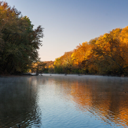
Yet, intermittently, public opinion seemed to forget about the pollution and take a more complimentary perspective regarding the river. Early pollution remediation efforts may have alleviated some of these concerns, or perhaps certain sections of the river simply evaded the pollution experienced by those close to the city center. The City Beautiful Movement, a civic ideology meant to beautify and celebrate cities in terms of design and leisure use of public spaces, popularized in the 1890s-1900s and may have factored into these sentiments. One such 1907 article described “country walking” on the riverfront as:
“Everybody who is not possessed of an automobile or carriage walks on Sunday. The bypaths of the river, creeks, and canal are thronged on Sunday afternoons with ‘hikers.’ They are out to see how nature is getting along and to drink in the pure fresh air of the country…” “No city in the country has it on Indianapolis for beautiful suburban scenery. I have wandered up and down every stream around here and there is something new to be seen every time I go back.”
The Great Flood of 1913 had a devastating impact on numerous communities along White River, revealing another fact – that beyond better pollution control, municipalities lacked the resources for better flood control as well as levee and dam maintenance. Soon after the flood, the pollution debate continued. John Diggs, an engineer and chemist for the water company, contended that the river was “seriously” polluted and advocated for better data collection in terms of pollution, wastewater management, and mortalities associated with the pollution. In addition, he compiled photodocumentation on behalf of the Indianapolis Water Works Company depicting sources of pollution on White River. By 1916, the City of Indianapolis, along with the businesses of Kingan & Co., Butchers’ Packing Co., Indianapolis Abbatoir Co., Moore & Co., Worm & Co., Frank Hilgemeier & Brother, Meier Packing Co., and Brown Brothers, were sued by 19 landowners – farmers and businesspersons – of Morgan County on the grounds of polluting the river. After some time, the City of Indianapolis was able to construct a disposal plant, which decreased river pollution, but by 1933, the City was sued again by downstream landowners because the City decreased plant operation as a cost-saving policy which resulted in an increase of 30% raw sewage entering the watershed. Disposal plants and dams were constructed to help ease the combined sewer overflow system, in which both stormwater runoff and wastewater are piped through the same infrastructure. But unfortunately under circumstances where the water flows too fast and too high, raw sewage gets kicked up through the system and into the river nevertheless.
As rivers flow downstream, similar concerns of Noblesville polluting the Village Lakes Reach and Indianapolis polluting the South Bluffs Reach and beyond continued through the 20th century. One such strategy to alleviate the White River was a sewer diversion project diverting some sewage to Fall Creek north of the City of Indianapolis. This ultimately diverted sewage into majority black neighborhoods, triggering an Environmental Protection Agency review of environmental racism. The EPA took the City to court under the Clean Water Act of 1972. The case finally settled in 2006, with an agreement to construct combined sewer overflow mechanisms that would reduce overflows of wastewater into the watershed. The project, known as Dig Indy, should be completed in 2025 and will include a 25-mile long deep rock tunnel. During litigation, White River was listed as one of the most polluted rivers, in part due to corn and soybean pesticides in 1997; two years later, an Anderson automaker dumped chemicals into the river upstream, causing a massive fish kill of 4.6 million fish.
Pollution would not be the only cause of harm for the river, however. Segregation would leave its mark on the river and residents. More so in Marion County, the City of Indianapolis became highly segregated in the early 1900s as the local black population increased during the Great Migration, and segregation intensified in the 1920s due to the rising popularity of the Ku Klux Klan. By 1937, most areas encompassing Center Township had been redlined – the discriminatory practice by which banks and mortgage lenders refused or limited loans and mortgages within specific geographic areas, particularly in older and inner-city neighborhoods, to non-white and/or low-income families by guidance of the Federal Housing Administration – either “Definitely Declining” or “Hazardous,” leading to a decrease in investment. Surprisingly, although the northern corridor of Indianapolis was labeled “Best” or “Still Desirable” in more affluent and white neighborhoods, many river enclaves were still devalued as “Hazardous.” “Hazardous” areas included parts of Rocky Ripple, Broad Ripple, Ravenswood and were in part devalued for their chronic flooding issues. Mid-20th century brought in additional suburbanization and white flight, causing many white families to move out while urban renewal and interstate highway construction displaced many black families. Besides residential segregation, public spaces were segregated, meaning whites had access to better and more public parks, pools, and beach front (such as the Riviera Club, Broad Ripple Beach, and Ravenswood Beach) whereas blacks only had access to Belmont Beach and Douglass Park.
In the last few decades, cities and towns along White River have begun to rethink their relationship to the riverway, particularly in Indianapolis. White River State Park was one of the first large efforts to redevelop a vast 250-acre industrialized area as an urban park with numerous cultural institutions, an amphitheater, and other amenities. In tandem, the Central Canal, essentially a mud trench, was redeveloped in the downtown area for the Pan Am Games as a beautification project, with an extension completed in 2001. Additional floodplain, stream protection, and environmental justice work continues. And recently, the White River Vision Plan was assembled, to think bigger regarding the 58 miles of White River within Hamilton and Marion counties on how to better protect, celebrate, and leverage this natural asset.
Tagged in: History, Storytelling