History, for many, brings to mind the seemingly endless list of names and dates we memorized during our years in school. I’m not going to bore you with names and dates here though. Instead, I want to examine another aspect of history: place. When I say place, I mean more than just a physical location you can find on a map, because a place is more than that. Places hold meaning and memories. It shapes who we are and has since time immemorial. Were I to ask you to take a moment and think about your favorite places, I doubt you would only think of physical ones. I imagine your mind would conjure up the memories associated with those places, and the ways they shaped who you are today. In the same vein, the history of Hamilton County has been impacted by place.
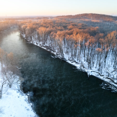
Although the Hamilton County Bicentennial focuses on the past 200 years, the history of the White River and this place begins over 20,000 years ago, when the Wisconsin glacier began to melt and altered the landscape of the Midwest. As it receded, it created the Great Lakes and the rivers that flow throughout the state. These rivers, and the fertile soil adjoining it, would attract many people through the years. And just as the glacier had altered the place, the place would alter the lives of those that called the land home.
Until the mid-1800s, rivers played an essential role in people’s lives. Early communities often were located along rivers because they provided food, water, and quick and efficient transportation. For example, thousands of years ago a group of people lived along the White River, as evidenced by the mound structures located at Mounds State Park in Anderson. While we know little of the people who constructed them, it is telling that these mounds are so close to the river. Angel Mounds, along the Ohio River, provides another example of early settlements being situated alongside rivers. When the French arrived in Indiana in the mid-1600s they encountered the Miami and Pottawatomie, both of which lived near waterways. The Pottawatomie occupied the northern section of the state, living along the Great Lakes and the St. Joseph River, while the Miami set up villages along the Wabash. While neither tribe had villages along the White River, it is likely that they utilized the land along the river as part of their hunting grounds.
As Europeans continued to move westward, the frequency of violent conflicts between settlers and Native Americans increased, often resulting in the displacement and forced westward removal of Native peoples. One such tribe were the Lenape, who came by invitation of the Miami to live along the White River following their removal from Ohio in 1795. Here the Lenape established a dozen villages up and down the White River, stretching from present-day Muncie to just a few miles south of Conner Prairie. It is also along the White River where William Anderson was elevated to principal chief of the Lenape, and arguably his ascension had been caused by the river. The history of this river was not only a source of good for the community, but it also could cause harm and ruin.

In their early Indiana years, the Lenape experienced plenty of ruin. Shortly after their arrival, the White River experienced multiple floods that wiped out crops leading to widespread famines. Simultaneously, the tribe suffered multiple epidemics that wiped out much of their older population. Up and down the river sacrificial feasts were held up to appease the spirits who appeared to be angered with them. When this failed to improve their situation, prophets arose declaring that witchcraft and the acceptance of the ways of the white man had been the cause of the anger. A group of young radicals seized control and commenced a witch hunt, leading to the execution of Chief Tatapaxsit and the ascension of Chief Anderson.
Although this land technically belonged to the Native Americans, missionaries and fur traders had established posts along the river, one to Christianize and the other to make money. Some of the first white settlers in this area, although not the first, were the Conner brothers, John and William. Fur traders from Michigan, the brothers arrived around 1800 and lived among the Lenape. After a few years, John moved towards Muncie and William moved further south to what is now Conner Prairie giving them access to the entire length of the occupied White River. Being on the river also allowed them to move furs quickly down the White River to the Wabash, and then off to market.
Rivers would continue to impact the history of Indiana and Hamilton County after statehood. When the legislature decided to relocate the capital to a more centralized location after gaining central Indiana in the Treaty of St. Mary’s, the commissioners settled on a site where the White River and Fall Creek met. They had met at the home of William Conner and then traveled south, surveying the land along the way. In choosing the confluence of the White River and Fall Creek, they hoped Indianapolis would flourish, just as Cincinnati had along the Ohio. Choosing a site along a major river meant steamboats would be able to reach the capital, connecting the heart of Indiana with the rest of the nation. Unfortunately, over the next decade or so, people began to realize the river was much too shallow for anything other than a flatboat. In 1831 a steamboat made it up the White River as far north as Indianapolis, the only one to do so, but it ended up stuck on a sandbar. I suppose you could say their hopes were scuttled.
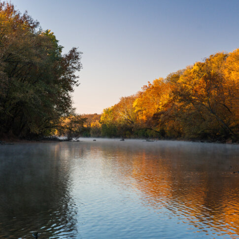
As the White River runs its winding course, it forms u-shaped bends referred to as “oxbows.” The land inside these oxbows is prone to flooding, making it near impossible for trees to take root and grow. This lack of deep-rooted trees made these lands ideal places to start a homestead since it didn’t require a lot of clearing to get crops in the ground. When settlers began arriving in the summer of 1819, they chose land around the oxbow at the intersection of 146th Street and River Road, now part of Beaver Materials. Nicknamed Horseshoe Prairie, the settlers were able to cultivate over 300 acres within a few years, but soon lost the land when John Conner bought it when it went up for official sale. John Conner ordered them to leave the land without paying for their improvements. Such was the nature of early 19th century land dealings.
The river’s early 19th century history is still felt by us today, although in ways that might surprise you. As the state continued to grow, and people began settling further from the White River, it would remain an important physical feature. This growing population meant the state needed improved ways to transport both people and goods, and instead of investing heavily in roads or railroads, the state decided to harness the power of the rivers through the construction of canals. This multimillion-dollar construction program, named the Mammoth Internal Improvement Act of 1836, aimed to build an extensive canal system to connect the state directly to the Eastern metropoles. These proposed canals would run alongside rivers, which would in turn provide water for the locks. The White River would become part of the Central Canal, which would connect the Wabash & Erie Canal in the northern part of the state with Indianapolis. The Central Canal would turn west at Alexandria, converge with the river at Strawtown, and then run alongside the river southwards through Indianapolis. Unfortunately, the plan failed due to multiple factors and within five years the state was forced to declare bankruptcy. This bankruptcy would lead to the new 1851 Constitution, still in effect today, banning the taking on of debt by the state with limited exceptions.
To learn more about Conner Prairie’s vision for the future, visit their website.

Tagged in: Conner Prairie, Fishers